Best Management Practice (BMP) Tracking
Best Management Practices (BMPs) is a general term for actions, practices or operations implemented with the intent or protecting or enhancing local natural resources. BMPs are implemented throughout the Napa River watershed to reduce the amount of fine sediment reaching Napa streams and/or to enhance the habitat quality of local streams through improved riparian shading, reduced streambank erosion and overall better stream function. As more BMPs are successfully employed over a greater spatial area within the Napa River Watershed, an improvement in salmonid migration, spawning and rearing habitat quality is expected. The primary goal for the Napa River Sediment TMDL is to protect and enhance salmonid populations through effective management actions that result in aquatic habitat improvement and conservation.
BMP Tracking is expressed in ITAS as the count and spatial extent of a variety of BMPs implemented in an effort to achieve the TMDL objectives.
Land Use Imporvement | BMP Type | BMP Implementation | BMP Tracking Metrics
Land Use Improvement
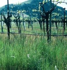
Declining aquatic habitat conditions within the Napa River watershed have been attributed to excessive fine sediment accumulation, channel incision, fish passage barriers, reduced summer-time baseflow, and subsequent higher water temperatures. BMPs are frequently installed or implemented by both public agencies and private landowners to improve the landscape condition of various land uses, including riparian habitat, roads, agricultural lands, and developed/urban lands. By land use, the implementation of BMPs is expected to:
Stream & Riparian Areas
-
Reduce and filter surface runoff (sediment, organic material, pesticides, nutrients)
- Restore riparian (aquatic) habitat communities
- Increase the quantity and quality of salmonid habitat
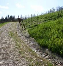
Paved and Unpaved Roads
- Reduce fine sediments eroding from road surfaces and drainages
- Control, disposal and timing of surface water runoff
- Improve water infiltration
Agricultural Lands
- Reduce soil erosion from storm runoff
- Cycle and filter excess nutrients before reaching waterways
- Increase soil organic matter
- Minimize the concentration of stormwater
- Improve water infiltration
Urban & Rural Developed Lands
- Improve stormwater quality
- Collect or direct water to improve infiltration
- Minimize potential entry of sediment into surface waters
BMP Type
In the ITAS, a collection of BMP types implemented to minimize water quality impacts have been explicitly defined by specific land use. The type of BMPs implemented in the watershed range from large scale stream/riparian restoration improvements, to stormwater treatment infiltration devices, to road improvement projects, to vegetation planting and maintenance efforts.
|
Location |
Sub-Location |
Type |
|
Stream & Riparian Areas |
On-bank |
|
|
In-channel |
||
|
Top of bank/floodplain |
||
|
Roads Paved & Unpaved |
|
|
|
Agricultural Lands |
|
|
|
Urban & Rural Developed Lands |
|
BMP Implementation
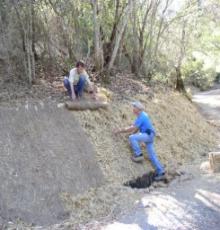
Efforst are underway to collect data from public agencies and private landowners throughout the Napa River watershed to summarize the areal extent (miles or acres, depending on BMP type) of BMPs implemented during each water year. This data is summed by subwatershed and uploaded to ITAS.
BMP Tracking Metric
ITAS summarizes the total areal extent of BMP implementation by BMP type by watershed. The target is an upward trend to total spatial area of BMP implementation over time. As the number and distribution of BMPs increases, sediment transport and loading (or delivery) to the stream system is expected to decrease and the quality of salmonid habitat is expected to increase. Additionally, coupling the implementation of BMPs with ITAS tracking of other metrics may provide information on which BMPs are more (or less) successful at providing water quality benefits. Overtime this type of accounting will help to inform future implementation priorities and public outreach efforts.