Road Condition
Road related erosion is identified in the Napa River Sediment TMDL as one of the two priority controllable sources of sediment to the Napa River stream network, the other being stream channel and bank erosion. Elevated contributions of fine sediment (sand and finer) to the stream essentially clog redds (salmon nests) and increase the frequency of egg mortality. Reducing the amount of fine sediment delivered to and accumulating within the stream bed can hep improve salmonid spawning habitat, a primary goal of the Napa River TMDL.
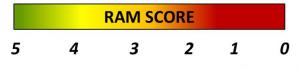
Road condition is defined as the relative risk that road derived sediment will be delivered to the local stream during a subsequent runoff event. Raod condition can be assessed in the field using a series of standardized observations and reporting formats using a scale 0-5. It is assumed that effective road improvement projects and associated maintenance action will result in improved and sustained of desired road conditions. Road condition data is expressed in ITAS as the percent of high priority road miles in good condition. The desired target is 70%.
Sediment from Roads | Rural Road RAM | Road Condition Evaluations | Road Condition Metric
Sediment from Roads: Sources and Treatment
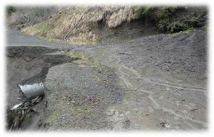
Unpaved roads, in particular, are a chronic source of sediment and larger volumes are transported into streams as a result of road surface wear due to traffic, road grading practices and poor road drainage. Both paved and unpaved roads constructed over perennial or ephemeral streams can fail during large storm events resulting in large pulses of episodic sediment input directly into the local surface waters. Roads can also cause landslides and other larger localized erosional features.
Both the risk and magnitude of the annual chronic and acute sediment inputs can be minimized by the implementation of proper road designs and effective maintenance BMPs. Napa County and the local municipalities have an active road maintenance and improvement program to minimize the amount of road related sediment impacts. In addition, the Napa Resource Conservation District (Napa RCD) provides a landowner outreach and road improvement program to assist land owners with implementing road improvement projects and other road maintenance BMPs to minimize the amount of road related sediment generated in areas draining to streams that are critical for the local salmonid populations. For more information about the RCD's road improvement program, contact Bill Birmingham at Napa Resource Conservation District at Bill@naparcd.org.
To learn more about making roads watershed and wallet friendly.
Rural Road RAM
The Rural Road Rapid Assessment Methodology (RAM) is a field assessment and information management system developed to evaluate and track the condition of paved and unpaved roads on a 0-5 scale. The tool is being cooperativelydesigned for Napa County stakeholders to directly meet the needs of local agencies, regulators and land owners. Rural Road RAM functions and features include:
- A technically defensible approach that leverages existing and scientific theory to capture sediment transport processes, identify key indicators of impaired vs desired road attributes, and develop robust scoring algorithms.
- Integrates a series of field observations to define relative road condition.
- Good condition includes: proper road drainage and adequately sized culverts or crossings (bridges, culverts, fords, etc.) that are expected to properly convey storm runoff surrounding the road with minimal erosion and associated delivery to the local stream.
- Degraded condition: excessive accumulation of runoff on the road surface side ditch that results in rills, gullies and other erosional features and/or relatively elevated risk of acute or episodic road failure, land slide or other significant erosional event during storm runoff and delivery to the local stream.
- Employs simple and repeatable road assessment methods to determine road condition on a relative 0 to 5 scale based on observation results.
- Automates data management and results reporting to evaluate and track the effectiveness of road maintenance and improvement actions by Napa resource managers and land owners. Rural Road RAM allows simple exports of annual RAM assessment results in a format directly importable to ITAS as miles of high priority roakds in good condition (>3. score).
Road Condition Evaluations
Using Rural Road RAM, Napa County stakeholders can inventory road sites in high priority areas where sediment transprot from roads is highly likely to reach anadromous (salmonid) streams. Trained field personnel can conduct Rural Road RAM observations to determine road conditions. Rural Road RAM integrates the observation results and reports a RAM score from 0-5 for each site. These results are automatically integrated by the RAM application to summarize the total miles of high priority road assessed and the total miles of those high priority roads in good condition. These results are directly input into ITAS annually by subwatershed.
 |
 |
| Ram Score 0 | Ram Score 5 |
Road Condition Metric
The target for road condition is to achieve 70% of high priority road miles are in good condition year after year. High priority roads are defined as roads that hydrologically connected (i.e. drain directly) to anadromous streams in the Napa River Watershed. Good conditiion is defined as a Rural Road RAM score >3.5, and the greater the distribution of roads in good condition the lower the sediment load contribution risk to the local stream. Tracking of road condition improvements over time will provide a regional demonstration of the cumulative effectiveness of road improvement and maitenance actions to reduce the risk of sediment delivery to local streams. It is assumed that a significant improvement in the condition of critical road networks within the Napa River Watershed will directly correspond to a sustained reduction in the amount of annual sediment loading to the local stream network, which in turn is expected to improve salmonid spawning and rearing habitat quality.
The ITAS 70% target is based on what is achievable and assumed to make a measurable improvemnt on fish spawning and rearing habitat quality. The determination of the ITAS target considers the practical lifespan of road treatments and conitinuous road maintenance based on climatic influences.