ITAS - Tracking Sediment Reduction
Napa River Sediment TMDL Implementation Tracking and Accounting System (ITAS)
Napa County, with help from several partners, has developed a Napa River Sediment Total Maximum Daily Load (TMDL) Implementation Tracking and Accounting System (ITAS). The work was funded in great part with financial assistance from the U.S. EPA. The tracking system is designed to account for required and recommended implementation actions prescribed in the Napa River Sediment Reduction and Habitat Enhancement Plan (Napa River Sediment TMDL). The Napa River Sediment TMDL was adopted as part of the Water Quality Control Plan for the S. F. Bay Basin in September 2009.
Objectives | Summary | Status | Contact
Objectives

The objectives of the ITAS are to:
- Identify progress towards achieving TMDL goals and compliance;
- Prioritize implementation actions;
- Inform management strategies; and
- Communicate the results to stakeholders, regulatory agencies, funders and policymakers.
Summary
Napa County contracted with Tetra Tech Inc. and 2ndNature LLC. to develop a web-based ITAS to assist the County and other responsible reporting entities in tracking their progress and implementation actions within the Napa River watershed that reduce sediment loading of waterways, improve aquatic and riparian habitat quality, and meet the objectives of the Napa River Sediment TMDL. The ITAS tracks performance measures to demonstrate compliance and relative effectiveness of specific watershed actions intended to control or reduce sediment delivery to the river system and improve overall stream function and health.
- Tracking of TMDL implementation actions and projects (BMPs - Best Management Practices) completed and ongoing throughout the Napa River watershed;
- Identification of metrics that communicate incremental progress of improvement actions implemented throughout the watershed, including the identification and inventory of existing data to support the metrics;
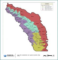
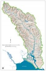
- Identification of the watershed boundaries by which specific tracking and accounting metrics are reported via a web-based system;
- Development of the ITAS in a web-based platform that is easily understandable and a meaningful way to inform state, local, and federal stakeholders of progress being made, and to encourage continued support and confidence in TMDL implementation actions; and
- Promotion of stakeholder and community collaboration across the watershed to foster effective and transparent communication at all levels of involvement from local implementers to regional policymakers.
Back to Top
Status
The ITAS is operational and can be accessed HERE. Ongoing system data entry and maintenance is facilitated by the Natural Resources Conservation Group of the Napa County Department of Public Works.