Napa River Basin
 The Napa River Watershed is almost entirely within Napa County (a small portion is also in Solano County). It is defined by Mt. St. Helena to the north, the Mayacamas Mountains to the west, Howell Mountain, Atlas Peak, and Mt. George to the east, and the Napa-Sonoma Marsh to the south. The Napa River runs through the center of the watershed on the valley floor, draining numerous tributaries along a 55 mile run from the headwaters of Mt. St. Helena to the San Pablo Bay. The Napa River winds through many types of landscapes: forested mountain slopes, vineyards, urban areas, open pasture, grasslands, industrial zones, and marshes.
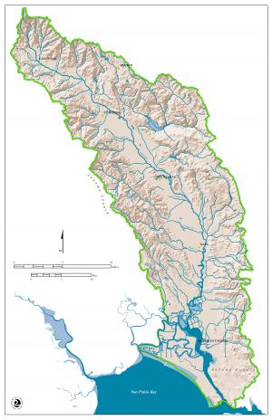
The Napa River Watershed is home to most of the residents and developed areas in the county. It is estimated that 95% or more of the entire population of Napa County live in the Napa River Watershed. Reservoirs in the watershed include Lake Hennessey, Lake Milliken, and Bell Canyon Reservoir. This watershed also provides habitat for many types of plants, fish, and wildlife. Chaparral, brackish and salt water marsh, vernal pools, forests, oak woodlands, grasslands, and riparian habitats can all be found in the watershed.
Source: Napa County Resource Conservation District
Learn more with maps!
The links below take you to interactive maps that illustrate different feaures of the watershed.